
Where Did The Name “Hyatts” Come From?
The short version, authored by resident historian Paul Bingle, appeared in the November 2024 CAH Newsletter
Updates still being posted…
Henry Adams Hyatt
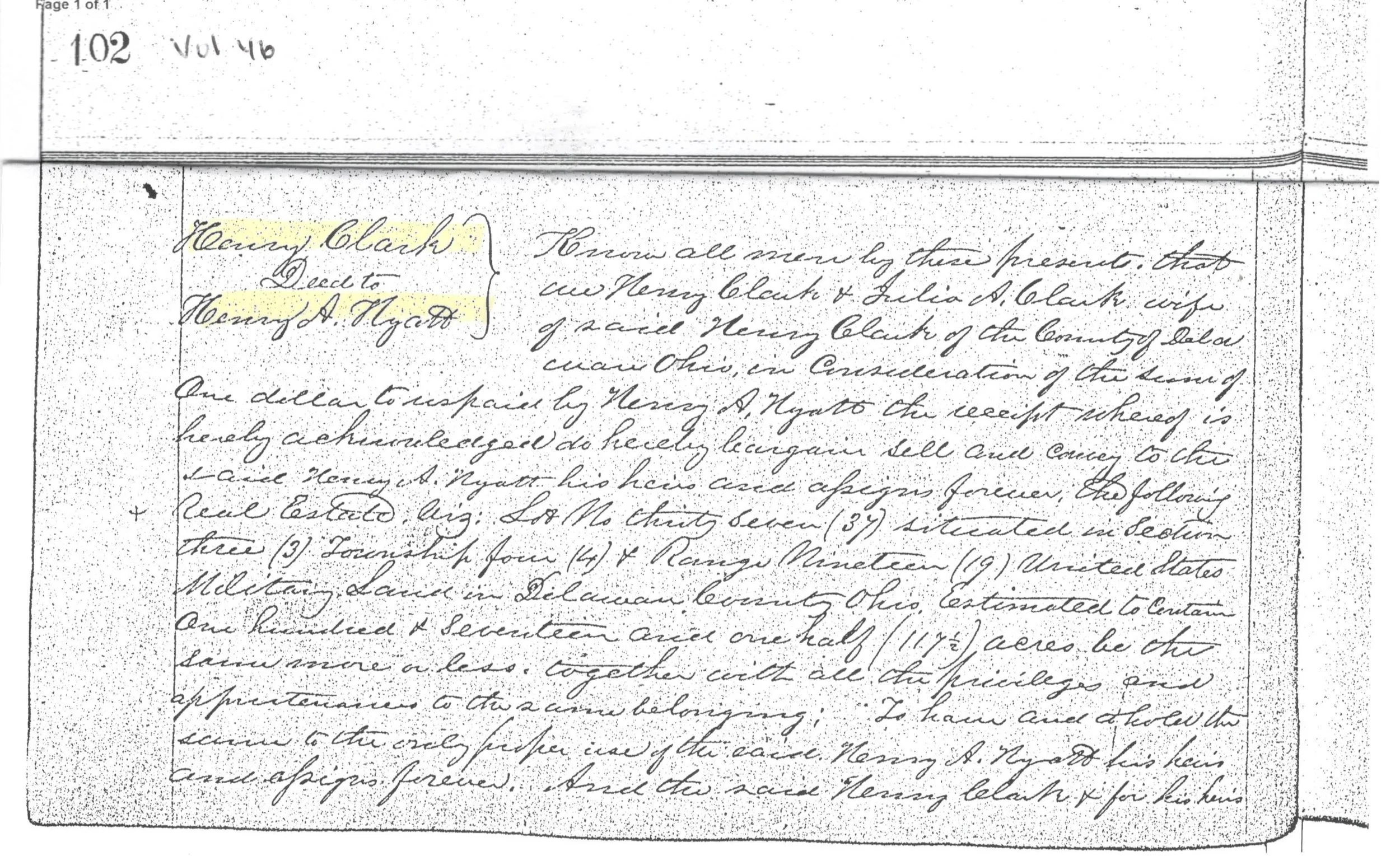
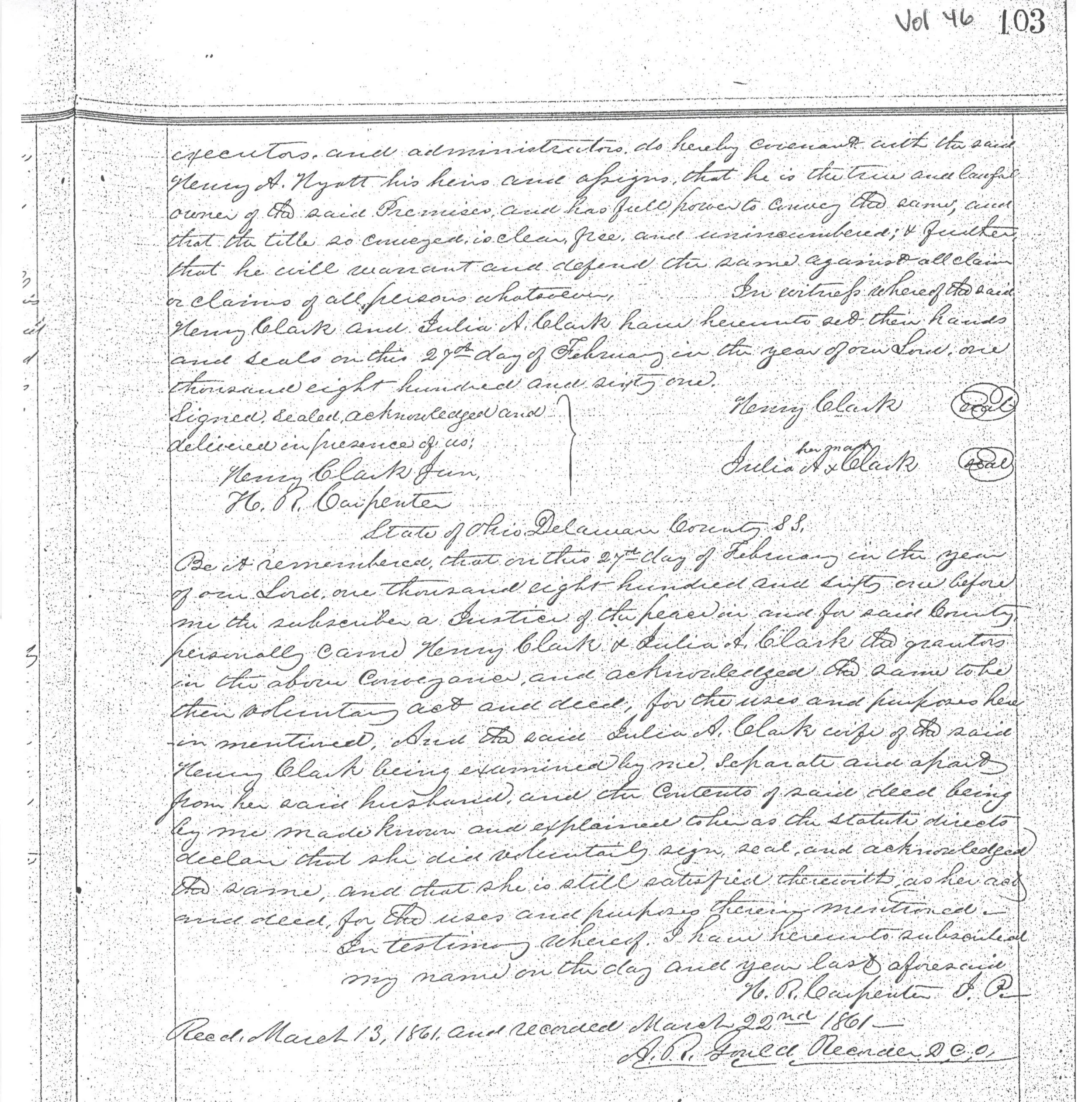
In 1861, Henry A. Hyatt [1] purchased a 111-acre tract of farmland [2] that is today on the north side of Hyatts Road (County Road 123) between Liberty Road (County Road 9) and the approximately Sawmill Parkway. The acquisition predated “improved” County roads and the railroad. Deed records of the era indicate that his extended family had owned numerous tracts of land in the County and within the city of Delaware.
The farmhouse and several barns on Mr. Hyatt’s original farmland were demolished in July (2024) [3]. The deed records indicate that he sold the farmland located immediately to the west of his Hyattsville, in two transactions of 25 acres to Isaac Rutherford in 1874 and 40 acres to George Curmode in 1877.
{Sidenotes: The local history books and records have very little information about Henry Hyatt and Hyattsville. His first wife died in 1859 after two years of marriage while they apparently lived in Knox County. I could not locate a record that he was a solider in the Civil War between 1861 and 1865. He outlived two of his four children and at least five of his six siblings. Adding to the mystique, his family gravestone does not have his name inscribed alongside his wife’s and children’s names (west side of the Myrtle Square section of Delaware’s Oak Grove Cemetery). He appeared to have owned land in several area locations, but he sold the farmlands after a limited time of ownership. Click here for my unfolding research.}
References:
[1] Born 8/4/1832 in Zanesfield (Ohio) and died 2/1/1911 in Columbus (Ohio). In the 1870 Census, he was identified as being a farmer. In the 1880 Census, he was identified as being a “Grain Dealer”. He is allegedly buried in Delaware’s Oak Grove Cemetery along with at least 17 relatives, including his wife Emma and two of their four children. For more information about Hyatt, click here.
[2] Deed recorded at the Delaware County Recorder’s Office (DCRO), Book/Volume 46, pages 102-3. Henry Clark to Henry A. Hyatt. Lot 37, Section 3, Township 4, Range 19, United States Miliary Land. (Land referenced as being 117.5 acres. Modern maps indicate that the referenced lot is 111 acres.) See “Maps and Deeds”.
[3] See "Maps and Deeds”.

Key Events - 1876
One Hundred and forty-eight years ago, on May 6, 1876, Mr. Hyatts recorded a formal plat for 32 lots at the northwest corner of today’s Liberty Road (named in the plat filing as "Delaware Street") and Hyatts Road (named in the plat filing as "Heck Street" and later referenced as "South Street"), naming the new village “Hyattsville” [4]. While there are differing records indicating which side of the tracks that the depot was built, the C&O site plans indicate that the passenger depot was on the west side. In 1879, he added 18 lots on the west side of the railroad [5].
A logical question is “why” create a village in the middle of farmland, miles from another village?
Foremost is that plans were underway to build a railroad from Columbus to Toledo to transport coal from southeastern Ohio to a new Lake Erie shipping dock [6]. When the Hocking Valley Railroad decided to build the rail line through Powell to Delaware, Hyatt negotiated to have an exclusive passenger and goods depot constructed on the land that he owned between the two villages [7]. His ‘outpost’ village was 4.1 miles north of Powell and 5.4 miles south of Delaware, otherwise connected only by dirt pathways for the horse drawn traffic of the day [8]. (Use CMH Railroad elevation and distance map) The railroad construction started in Delaware in 4/29/1876 and, amazingly given the remote location and rarity of powered equipment - connected with Columbus several months later [9]. (The connection to Toledo was completed on 1/10/1877.) [10]
References:
[4] Plat recorded at the DCRO, Plat Volume 2, page 264. See “Maps and Deeds”.
[5] Amended plat recorded at the DCRO, Plat Volume 2, page 283. See “Maps and Deeds”.
[6] “Columbus Railroads” online.
[7] Deed from Hyatt to "Columbus & Toledo Railroad Company" was recorded on June 5, 1876 (DCRO Book/Volume 69, pages 274-5.) See “Railroad Maps & Photos”.
[8], [9] & [10] “Columbus Railroads” online.

Hyattsville versus Hyatts: 1
An interesting situation contributed to the Hyattsville location. The steam engine drawn trains of the day functioned best on flat or very gentle sloping grades. The elevation change between Columbus and Hyattsville is approximately 218 feet [11]. The steep grade challenged the steam engines. It was necessary that an extra steam engine be added to surmount the so-called “Powell Hill”. Northeast of the Rutherford Road crossing, the railroad had a “wye” track that allowed the added “helper engine” to be detached and turned around [12] for a return run to Columbus. The remaining steam engine needed to be restocked with water before continuing its run to Delaware and Marion.
The railroad designated the rail stop as “Hyatts” [13]. The depot and platform, the third side track, and water tower (east side of the tracks) [14] are long gone – but there are two water supply lakes still remaining. Hidden on the west side of the tracks, in the soon to be MI Homes subdivision, is a small lake. Within the present Swan Lake Events site on the east side is a larger pond [15]. Water was pumped from the ponds into an elevated water tower alongside the railroad tracks. (No photos have been discovered.) C&O Railroad steam engines were discontinued in Ohio by 1952 and thus the need for the watering facility ended [16]. The east lake and adjoining land were sold by the railroad in 1997 [17].
Note that railroad depots normally included the area’s telegraph office.
References:
[11] “Columbus Railroads” online.
[12] “The Chesapeake & Ohio Historical Magazine”, Issue October 2011, article “xxx”.
[13] Cite 19xx railway schedule. See “Train Schedules”. See “Railroad Maps & Photos”.
[14] Reference – C&O right of way maps via the C&O Historical Society. See “Railroad Maps & Photos”.
[15] Cite reference – C&O right of way map VM-HV-V2-18 dated June 30, 1915. Courtesy C&O Historical Society.
[16] C&O Historical Society document research by P. Bingle. A photograph of the water pillar was not discovered but it was referenced in the C&O records held by the C&O Historical Society. See “Railroad Maps & Photos” for picture of the Powell water facilities.
[17] Deed between CSX Transportation and Paul & Phillip Tackett recorded on 3/4/1997 at the DCRO, Book/Volume 619, pages 323-330. See “Maps and Deeds”.


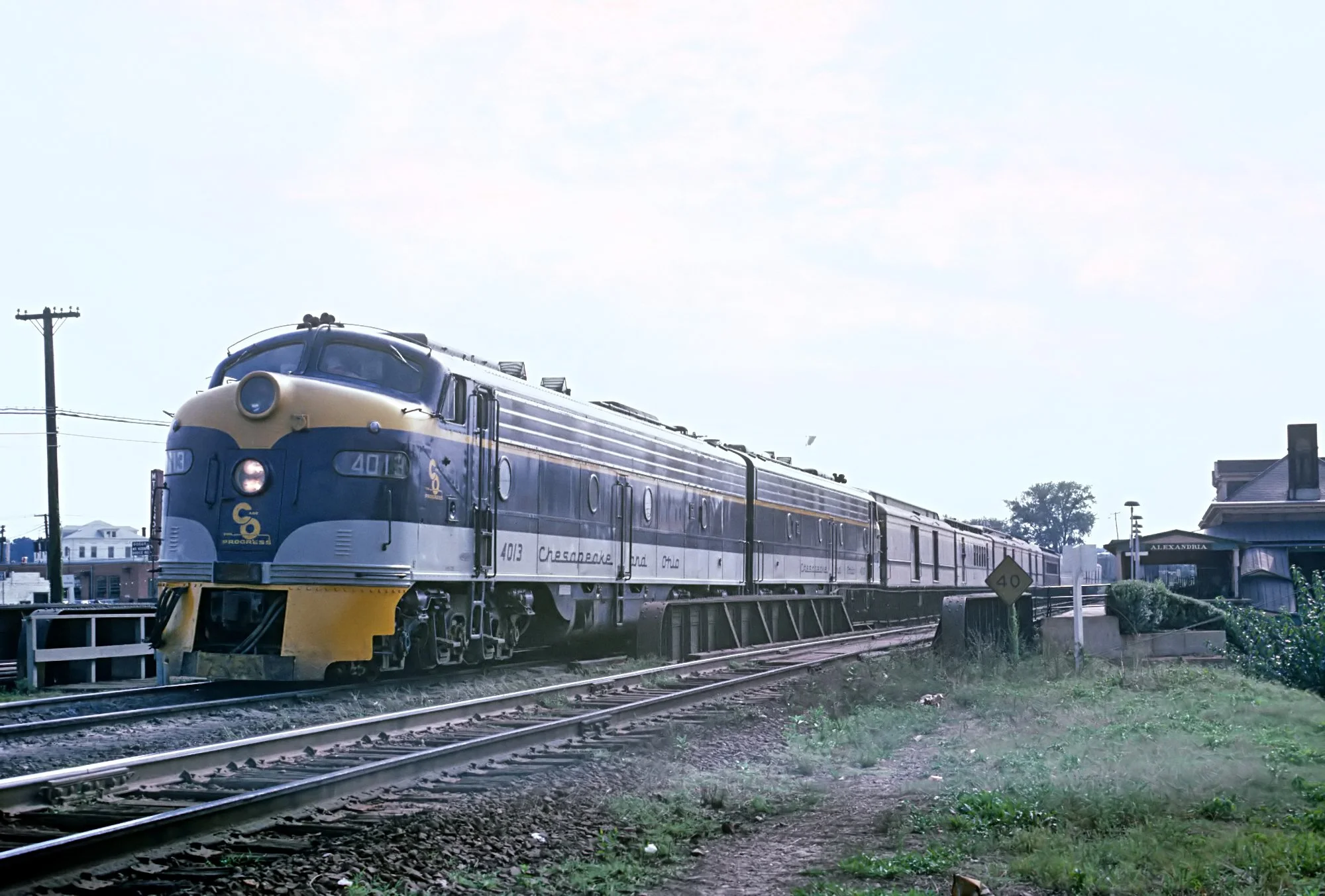
Passenger Trains
In the heydays of passenger train service, there were six passenger trains daily traveling between Detroit and Columbus [18]. Two regularly stopped at Hyatts and the other four stopped when the rail station had its “stop signal” visible or when there was a passenger with a ticket to Hyatts. By 1938, the stops had ended in favor of the Delaware station stop. The last run of “The Sportsman” passenger train was on 4/30/1971 [19].
On the “Columbus Railroads” website, stories about the rail line include a reference to The Sportsman passing thru the area at night at speeds between 80 and 100 miles per hour.
The main purpose of the railway was to transport coal, and to a lesser extent, grain and lumber. In the early days, in the absence of paved roads, the railroad was an opportunity for farmers and local mills to both transport and to receive goods. As the County’s roadway system improved in the 1920’s, the transportation modes changed.
The former double track between Hyatts and Fostoria was removed between 1972 and 1981 [20].
(Sidenote: the accompanying two photos of the passenger trains were taken in locations not in our area but are of the trains that visited or passed through Hyatts.)
Reference:
[18] Cite reference – xx Hocking Valley Railroad and Columbus & Toledo Railroad xx schedules. See “Train Schedules”.
[19] & [20] “Columbus Railroads” online.

Hyattsville versus Hyatts: 2
The first lots were sold by Hyatt in 1877 [21]. The cornerstone “Lot 1” was purchased by the Methodist Episcopal Church 1884 [22]. (According to deed transfers, the church was originally going to be built west of the railroad.) All of the initial property deeds identified the lots as being a part of the “Plat of Hyattsville”. Given that documents were handwritten, occasionally, the spelling was “Hiattville” and “Hyattville”.
A post office called “Hyattville” was established in 1877 [23] with Mr. Hyatt as its postmaster. The post office closed in 1908.
Thus maps of the times had differing names and thus written history stories lent to the ongoing name confusion. Perhaps as the final government authority, of note is that in March 1904, the United States Geological Survey officially recognized the name “Hyattville” (excluding the “s”) [24]. On January 1, 1967, they adopted the name “Hyatts”. (There was another Ohio village named Hyattsville in Miami County that was founded in 1833 and is today a part of Tipp City [25].)
References:
[21] Deed from H.A. Hyatt to Johnson Whiting for Lot 2, recorded March 31, 77, DCRO Deed Volume 70, page 195. See “Maps and Deeds”.
[22] Deed recorded at the DCRO on August 14,1884, Book/Volume 84, page 250.
[23] Per US Postal Office Application dated October 1876 and submitted by Henry A. Hyatt. See “Post Office”.
[24] USGS’s Geographical Names Information System.
[25] Miami County Ohio online history link.

Schools Become a Park
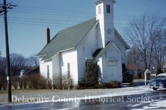
At the northeast corner of Liberty and Hyatts once was a township school site. In 1914, a brick schoolhouse for grades K-12 was opened [26]. The school closed in 1973 and the building was later torn down and is today site of Liberty Township’s Hyatts Park with its shelter house and baseball diamond.
In regard to Hyatts Road – the road was originally called County Road 123. As car travel became more dominant, in Ohio, county roads evolved to reflect the names of the community that the roadway connected or the largest community that the road passed through.
Reference:
[26] Per the Olentangy School District’s online “History” webpage.
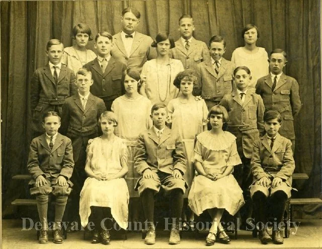
Hyatts School Class of 1929. Photo from the Delaware County Historical Society achieves.

Hyatts original and new school buildings - 1915 where Hyatts Park is located today. Photo from the Delaware County Historical Society achieves.
